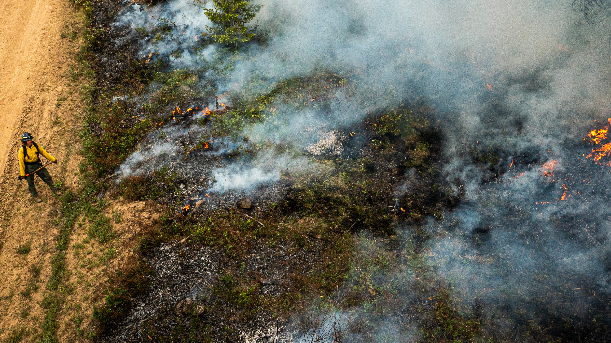
This research effort tackles the challenges that simultaneous megafires currently pose to decision makers and stakeholders, and supports proactive planning for future scenarios to mitigate risk (NSF Growing Convergence Research #2019762). Megafires are fires that are unusually large or that require a complex and aggressive firefighting response because of dramatic threats to lives, property, and/or infrastructure. When multiple megafires occur simultaneously, firefighting resources may be strained beyond capacity with catastrophic results. To successfully advance the frontiers of fire science and management to mitigate risk at the intersection of natural and human systems, we are developing a highly convergent approach in a team comprised of researchers from University of Washington, NCAR (National Center for Atmospheric Research), and University of California, Merced. We bring expertise in decision science, climate science, statistics, and fire science to our collaboration with on the ground decision makers including fire managers, fire ecologists, and land managers for tribal and US government agencies.
We aim to strengthen risk management related to wildfire impacts with improved climate projections in support of decisions regarding land use, fuel and land management, and wildfire suppression, thereby helping to safeguard against the future loss of life, property, infrastructure, and natural resources.
Please contact Alison Cullen alison@uw.edu with questions or to inquire about partnership opportunities.


Data Visualizations
Historic Data
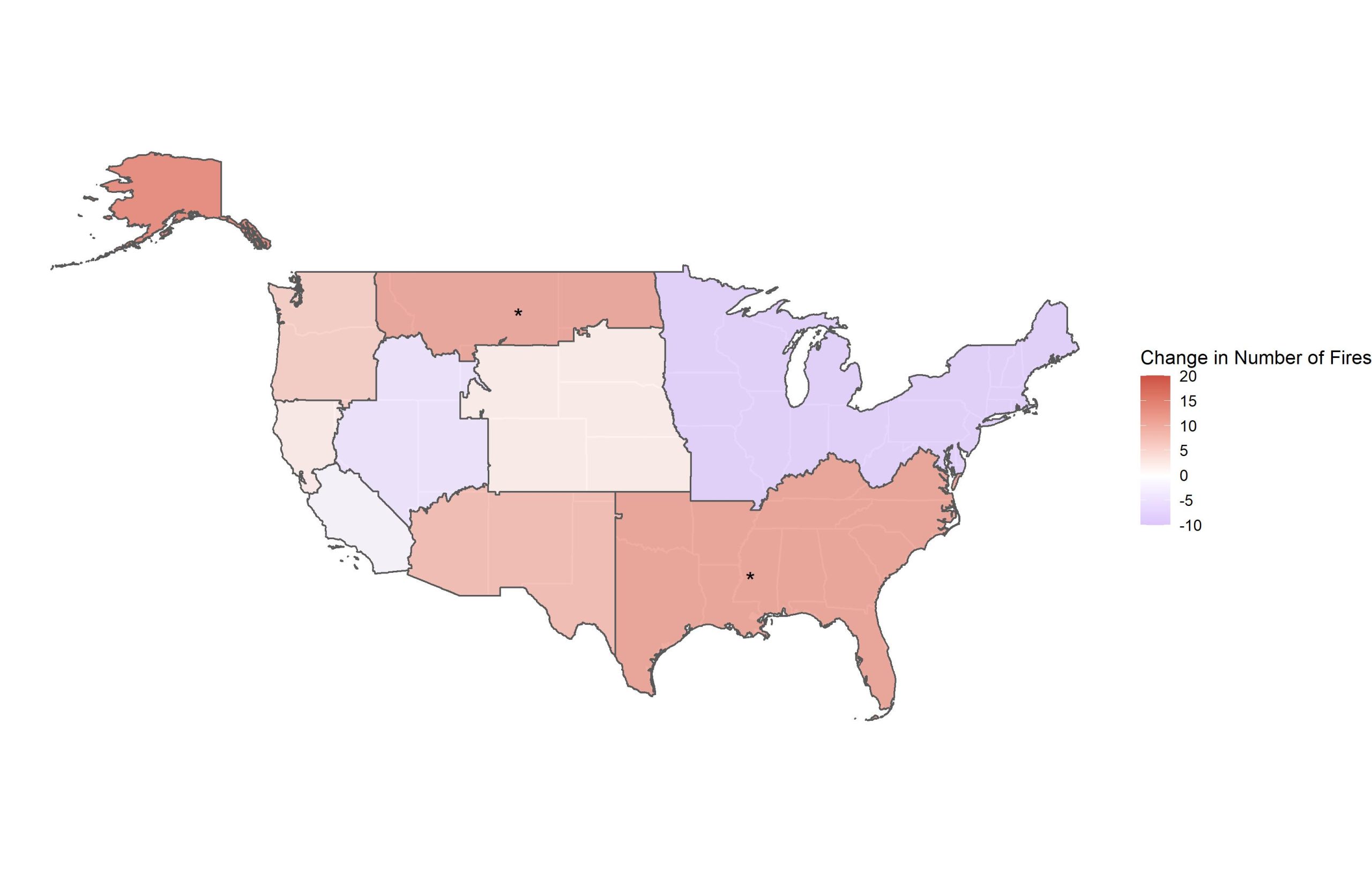
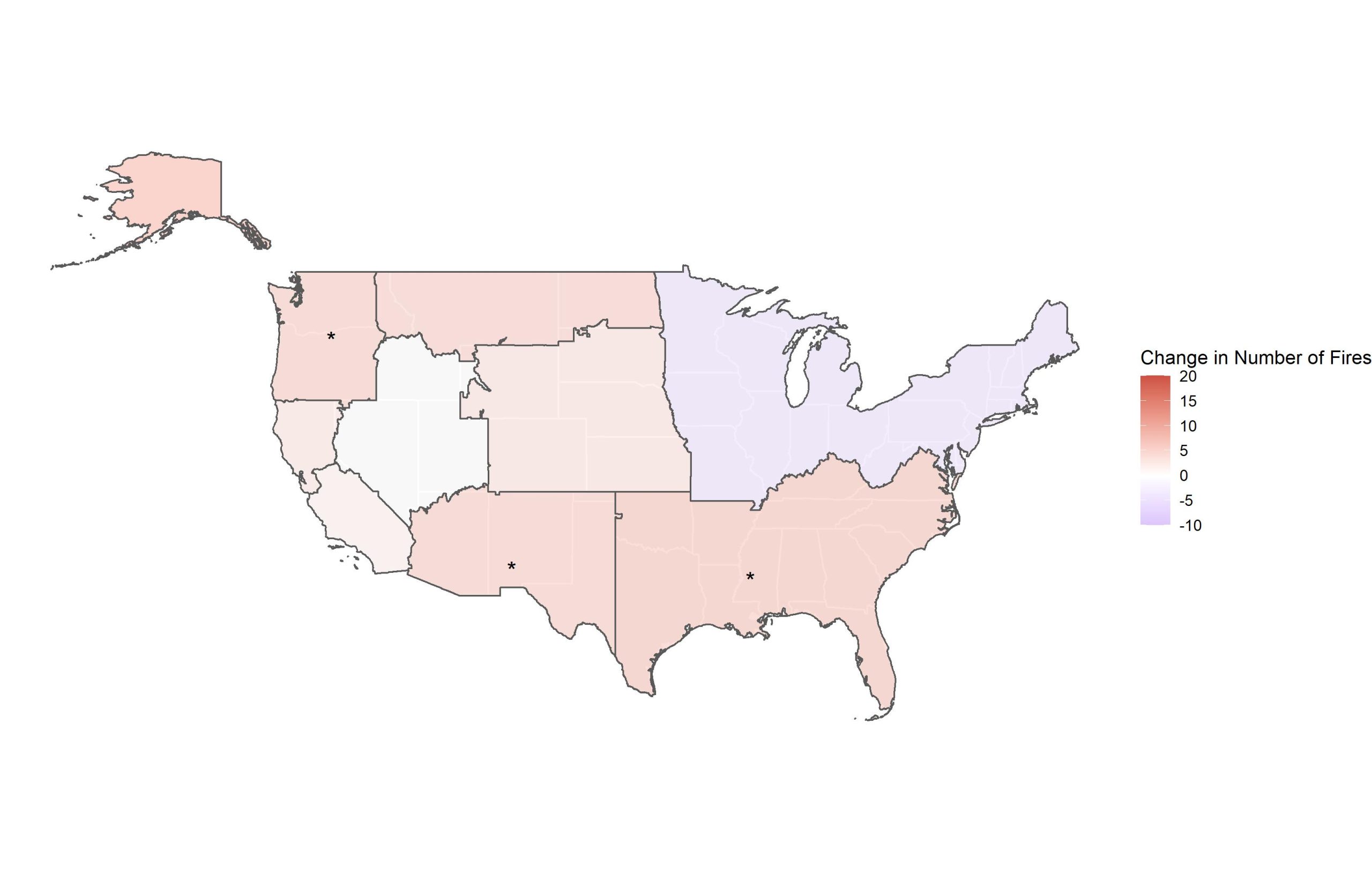
Change in simultaneous occurrence of 1000+ Acre and 75th Percentile fires, comparing 1984-2001 to 2002-2019. Both maps are divided into regions, with each region representing one GACC. The first corresponds to all large fires (ALF, 1000+ acres) while the second panel corresponds to 75th percentile fires (VLF), as determined for each GACC. The shading of each region indicates the change in number of ALF or VLF, respectively, between the two time periods. Red represents an increased number of fires, while blue represents a decreased number of fires. More large fires (1000 acres or greater) occurred during the peak month of simultaneity in the more recent time period, i.e., in 2002-2019 relative to 1984-2001. Statistical significance of the change in number of fires is denoted with asterisks, (*) corresponds to p < 0.05, (**) corresponds to p < 0.01 and (***) correspond to p < 0.001. Data on simultaneous wildfire occurrence come from the Monitoring Trends and Burn Severity (MTBS) project. Approach is based on Podschwit & Cullen (2020). This visualization was made as part of NSF Growing Convergence Project 2019762.
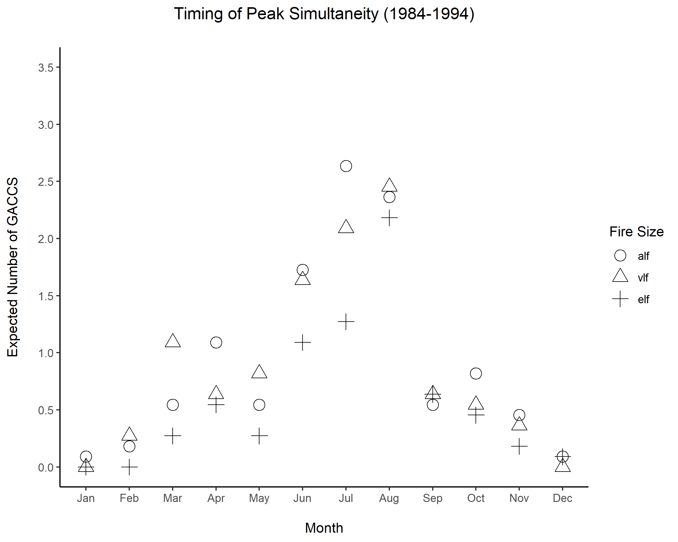
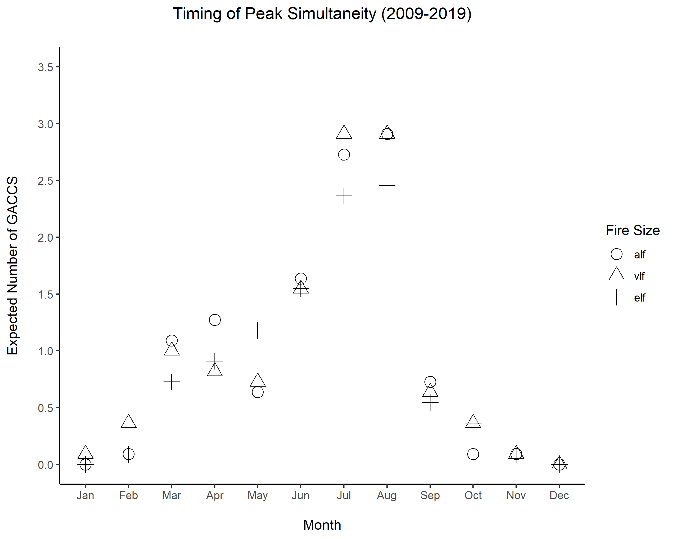
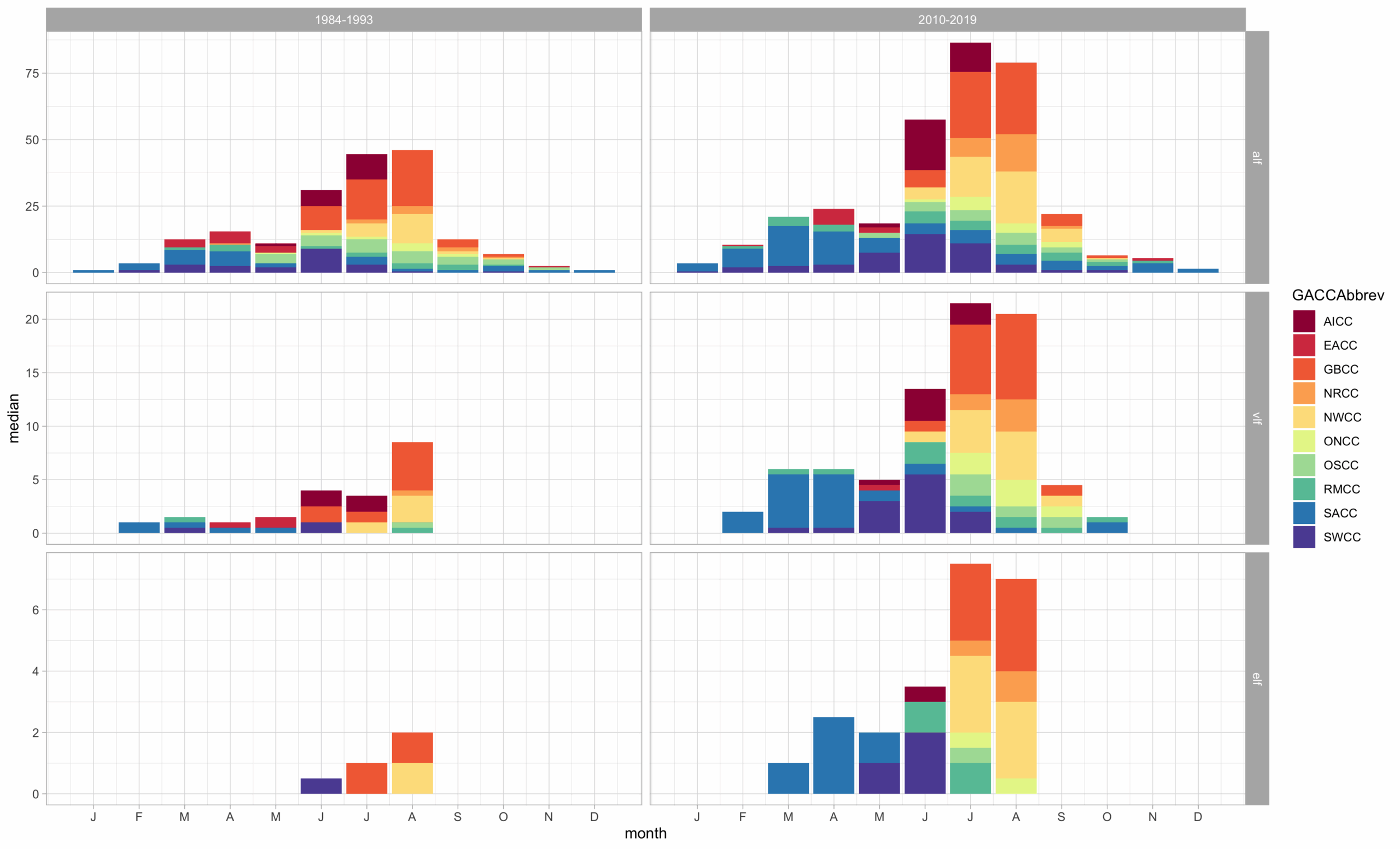
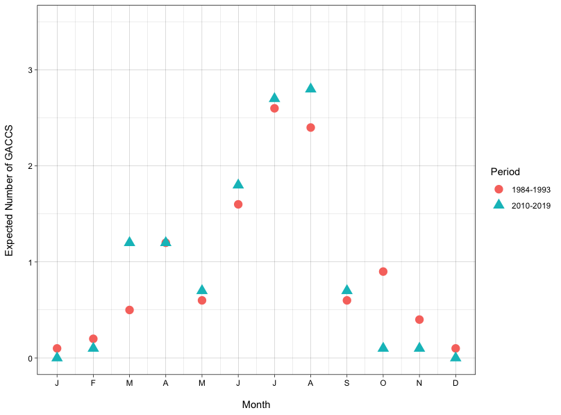
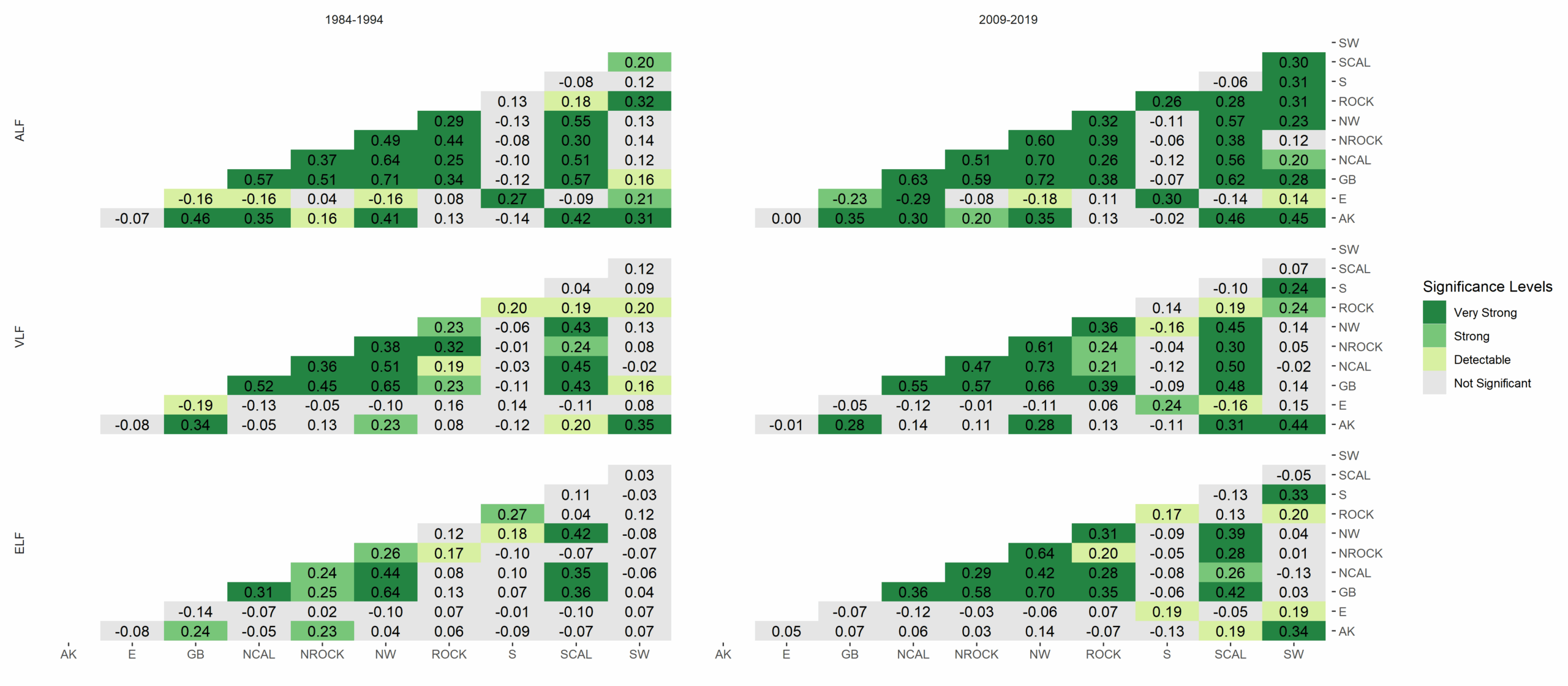
A decade to decade comparison of expected number of Geographic Area Coordination Centers (GACCs) that have peak simultaneity during the same calendar month. Peak simultaneity is defined as the greatest number of simultaneous fires occurring during the same calendar month in a calendar year. Each shape corresponds to a fire size definition: 1000+ acres (all large fires, or ALF) are circles, 75th percentile (very large fires, or VLF) are triangles, and 90th percentile (extremely large fires, or ELF) are plus signs. Percentiles are determined within-GACC. For 2009-2019 (right) on average more GACCs experienced simultaneity at the same time in summer months than occurred in 1984-1994 (left). Data on simultaneous wildfire occurrence come from the Monitoring Trends and Burn Severity (MTBS) project. Approach is based on Podschwit & Cullen (2020) https://doi.org/10.1071/WF19150. This visualization was made as part of NSF Growing Convergence Project 2019762
Data Projections
Research Goals, Questions, Hypotheses
Our overall research goal is to understand current and future wildfire characteristics to support fire-related decisions throughout the 21st century in the face of resultant suppression resource scarcity and competition in the US. This project will model future patterns and uncertainty in the simultaneous co-occurrence of megafire events to inform risk management.
Research Questions
- How will climate change alter future patterns of wildfire, particularly co-occurring megafires?
- What implications does this hold for risk management decisions?
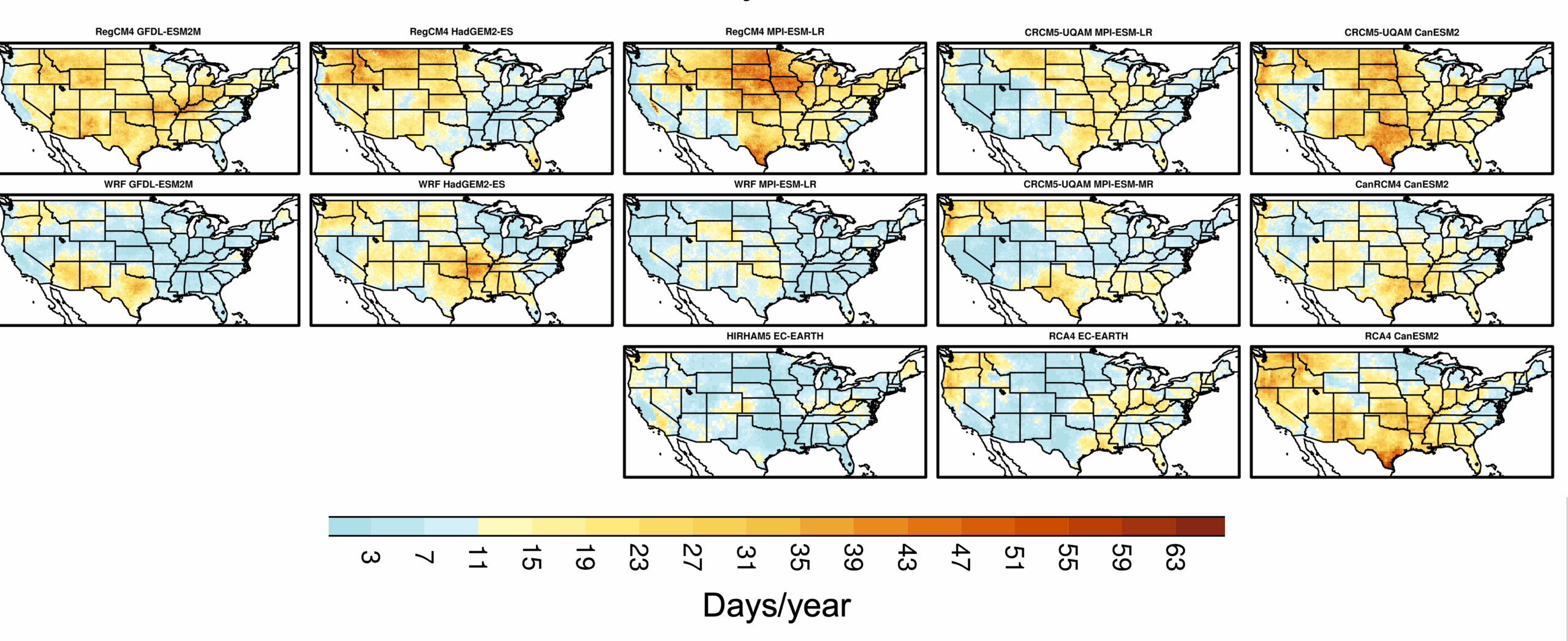
We are developing statistical models to represent relationships between biogeophysical and human factors (e.g., ignitions, suppression policy, land and fuel management) and firefighting resource demand at geographical scales relevant to firefighting management decision-making. These resource demand and risk management models will be based on wildfire characteristics, climate, weather, and land history covariates. We are evaluating climate change impacts on ignition patterns and on wildfire risk with regional climate model projections from NA-CORDEX, and observations from the gridMET dataset, by looking at fire danger indices in concert with projected spatiotemporal patterns in anthropogenic activities associated with human-caused fires, as well as diagnostics for lightning activity.
Hypotheses:
- We hypothesize that ignition efficiency will increase further with warming, facilitating increased lightning-ignitions, and consequently increases in simultaneous wildfire events.
- We hypothesize that a positive feedback may occur where fire suppression resources at the national level become strained, reducing the efficacy of managing active fires and new ignitions, and further increasing resource strain and relative burned area.
- We hypothesize that short term fire management decisions (e.g., both fuel management and fire suppression) have significant delayed impacts, and demand innovative scientifically supported decision tools that explicitly account for climate change and the continuing interaction of natural and human systems.
Publications
- Cullen AC, Bradbury N, Humphrey R, Kenig-Ziesler A, Kessenich L, McCrary R, McGinnis S, Prichard S, Abatzoglou JT, 2026, Lessons learned through convergence research applied to wildfire risk mitigation, Environmental Science & Policy, Volume 181, 104423, ISSN 1462-9011.
- Yin C, Abatzoglou JT, Jain P, Sadegh M, Flannigan M, Jones MW, 2026 Fire weather waves drive extreme fires globally, Communications Earth and Environment, doi:10.1038/s43247-026-03858-5
- Kalashnikov DA, Abatzoglou JT, Williams EL, Yin C, Gurazada M, Kumar M, et al. Heatwaves enable wildfire activity in the western United States. Sci Adv. 2026 Jul 1;12(25):eaea1277. doi:10.1126/sciadv.aea1277
- Kumar, M, Abatzoglou JT, Sadegh M, Kolden CA, Residential structure survivability to large wildfires in the United States. Earth’s Future (2026), doi:10.1029/2026EF008372
- Cunningham CX, Abatzoglou JT, Kolden CA, Williamson GJ, Steuer M, Bowman DMJS. Climate-linked escalation of societally disastrous wildfires. Science (1979). 2025 Oct 2;390(6768):53–8. doi:10.1126/science.adr5127
- Kenig-Ziesler A, Cullen AC, Belval EJ. A Quantitative Analysis of Firefighter Availability and Prescribed Burning in the Okanogan–Wenatchee National Forest. Fire. 2025; 8(5):167.
- Cunningham CX, Abatzoglou JT, Ellis TM, Williamson GJ, Bowman DMJS. Wildfires will intensify in the wildland-urban interface under near-term warming. Commun Earth Environ. 2025;6(1):542. doi:10.1038/s43247-025-02475-y
- Kalashnikov DA, Abatzoglou JT, Davenport F, Labe ZM, Loikith PC, Touma D, et al. Prrojections of Lightning-Ignited Wildfire Risk in the Western United States. Earths Future. 2025 Aug 1;13(8):e2025EF006108. doi:10.1029/2025EF006108
- Bradbury NP, Cullen AC. Risk Factors and Wildfire Mitigation Planning by Public Utilities in Washington State. Fire. 2025; 8(3):118.
- Kalashnikov, D. A., Davenport, F. V., Labe, Z. M., Loikith, P. C., Abatzoglou, J. T., & Singh, D. (2024). Predicting cloud to‐ground lightning in the western United States from the large‐scale environment using explainable neural networks. Journal of Geophysical Research: Atmospheres, 129, e2024JD042147.
- Jones, M. W., Veraverbeke, S., Andela, N., Doerr, S. H., Kolden, C., Mataveli, G., Pettinari, M. L., Le Quéré, C., Rosan, T. M., van der Werf, G. R., van Wees, D., & Abatzoglou, J. T. (2024). Global rise in forest fire emissions linked to climate change in the extratropics. Science, 386(6719), eadl5889.
- Jorge, A. L., Abatzoglou, J. T., Fleishman, E., Williams, E. L., Rupp, D. E., Jenkins, J. S., Sadegh, M., Kolden, C.A., Short, K.C., (2025). COVID-19 fueled an elevated number of human-caused ignitions in the western United States during the 2020 wildfire season. Earth’s Future, 13, e2024EF005744.
- Kumar, M., AghaKouchak, A., Abatzoglou, J.T. Sadegh, M. (2025). Compounding effects of climate change and WUI expansion quadruple the likelihood of extreme-impact wildfires in California. npj Nat. Hazards 2, 17.
- Yin C, Abatzoglou JT, Jones MW, Cullen AC, Sadegh M, Wang J, et al. Increasing synchronicity of global extreme fire weather. Sci Adv. 2026 Jul 1;12(8). doi:10.1126/sciadv.adx8813.
- Humphrey R and Abatzoglou JT, (2026 accepted, forthcoming), Synoptic Weather Patterns Associated with Extreme Fire Spread in the Pacific Northwest, Int. J. Wildland Fire. DOI:10.1071/wf25144
- Abatzoglou, J.T., Kolden, C.A., Cullen, A.C., Sadegh, M., Williams, E.L., Turco, M., Jones, M.W., (2025), Climate change has increased the odds of extreme regional forest fire years globally, Nature Communications 16, 6390.
- Kessenich, L., M. Bukovsky, S. McGinnis, L. Mearns, J. Abatzoglou, A. Cullen, 2025. “Multi fire index examination of future climate change affecting wildfire seasonality and extremes in the continental United States.”Journal of Applied Meteorology and Climatology, 64, 1851–1866, https://doi.org/10.1175/JAMC-D-24-0230.1.
- Seydi S, Abatzoglou JT, Jones MW, Kolden CA, Filippelli G, Hurteau MD, et al. Increasing global human exposure to wildland fires despite declining burned area. Science (1979). 2025 Aug 21;389(6762):826–9. doi:10.1126/science.adu6408
- Cullen AC, Goldgeier B, Abatzoglou JT, Belval E (2024) Characterising ignition precursors associated with high levels of deployment of wildland fire personnel. International Journal of Wildland Fire 33, WF23182.
- Kolden, C. A., Abatzoglou, J. T., Jones, M. W., & Jain, P. (2024). Wildfires in 2023. Nature Reviews Earth & Environment, 5(4), 238–240.
- Swain, D. L., Abatzoglou, J. T., Kolden, C., Shive, K., Kalashnikov, D. A., Singh, D., & Smith, E. (2023). Climate change is narrowing and shifting prescribed fire windows in western United States. Nature – Communications Earth & Environment, 4(1), 340.
- Humphrey R, Saltenberger J, Abatzoglou J, Cullen A, 2024, Near-term fire weather forecasting in the Pacific Northwest using 500-hPa map types, International Journal of Wildland Fire, 33(5). WF23117. Winner of the William M. Zumeta Doctoral Research Award 2024 University of Washington.
- Stoof, C.R., de Vries, J.R., Ribau, M.C., Fernandez, M.F., Flores, D., Villamar, J.G., Kettridge, N., Lartey, D., Moore, P.F., Thacker, F.N., Prichard, S.J., Tersmette, P., Tuljtel, S., Verhaar, I., and Fernandes, P.M. 2024. Megafire: An ambiguous and emotive term best avoided by science. Global Ecology and Biogeography 33: 341-351.
- Bloem S, Cullen AC, Abatzoglou JT, Mearns LO, Belval E, 2024, Drivers of international fire management personnel deployed to the United States, International Journal of Wildland Fire.
- Skinner H, Prichard SJ, Cullen AC, 2024, Decision Support for Landscapes with High Fire Hazard and Competing Values at Risk: The Upper Wenatchee Pilot Project, Fire 2024, 7(3), 77.
- Abatzoglou JT, McEvoy DJ, Nauslar NJ, Hegewisch KC, Huntington JL (2023) Downscaled subseasonal fire danger forecast skill across the contiguous United States, Atmospheric Science Letters (24):8.
- McGinnis S, Kessenich L, Mearns L, Cullen A, Podschwit H, Bukovsky M (2023) Future regional increases in simultaneous large Western USA wildfires, International Journal of Wildland Fire 32 (9): 1304 –1314.
- Abatzoglou, J. T., Kolden, C. A., Williams, A. P., Sadegh, M., Balch, J. K., & Hall, A. (2023). Downslope wind-driven fires in the western United States. Earth’s Future, 11, e2022EF003471.
- Cullen AC, Prichard SJ, Abatzoglou JT, Dolk A, Kessenich L, Bloem S, Bukovsky MS, Humphrey R, McGinnis S, Skinner H, Mearns LO. 2023. Growing convergence research: Coproducing climate projections to inform proactive decisions for managing simultaneous wildfire risk, Risk Analysis 43:11, pp 2262-2279.
- Kalashnikov DA, Abatzoglou JT, Nauslar NJ, Swain DL, Touma D, and Singh D. (2022) Meteorological and geographical factors associated with dry lightning in central and northern California. Environ Res: Climate.
- D’Evelyn, S., Jung, J., Alvarado, E., Baumgartner, J., Caligiuri, P. Hagmann, K., Henderson, S., Hessburg, P., Hopkins, S., Kasner, E., Krawchuk, M., Krenz, J., Lydersen, J., Marlier, M., Masuda, Y., Metlen, K., Mittelstaedt, G., Prichard, S., Schollaert, C., Spector, J. (2022). Wildfire, smoke exposure, human health, and environmental justice need to be integrated into forest restoration and management. Current Environmental Health Reports. 9: 1-20. 10.1007/s40572-022-00355-7.
- Bloem S, Cullen A, Mearns L, Abatzoglou J, 2022, “The role of international resource sharing arrangements in managing fire in the face of climate change. Fire, 5(4), 88.
- Hawkins LR, Abatzoglou JT, Li S, Rupp DE. (2022) “Anthropogenic influence on recent severe autumn fire weather in the west coast of the United States” Geophysical Research Letters 48(8).
- Gaines W, Hessburg P, Aplet G, Henson P, Prichard S, Churchill D, Jones G, Isaac DJ, and Vynne, C. (2022) “Climate change and the Northwest Forest Plan: managing for dynamic landscapes.” Forest Ecology and Management 504: 119794.
- Jain, P, Castellanos-Acuna, D, Coogan, SCP., Abatzoglou, JT & Flannigan, MD “Observed increases in extreme fire weather driven by atmospheric humidity and temperature.” (2021). Nat. Clim. Chang. doi:10.1038/s41558-021-01224-1.
- Abatzoglou, JT, Battisti, DS, Williams, AP et al. “Projected increases in western US forest fire despite growing fuel constraints.” (2021). Commun Earth Environ 2, 227.
- Abatzoglou, JT, Cullen, AC and Prichard, S, Synchronous fires and fire danger challenge US capacity to respond, The Climate Circulator, September 29, 2021.
- Prichard SJ, Hessburg PF, Hagmann RK, Dobrowski S, Povak NA, Hurteau MD, Kane VR, Keane RE, Kobziar LN, Kolden CA, North M, Parks SA, Safford HD, Stevens JT, Yocom LL, Churchill DJ, Gray RW, Huffman DW, Lake FK, and Khatri-Chhetri P. (2021). “Adapting western North American forests to climate change and wildfires: ten common questions,” Invited feature. Ecological Applications.
- Abatzoglou JT, Rupp DE, O’Neill LW and Sadegh M. (2021). “Compound Extremes Drive the Western Oregon Wildfires of September 2020” Geophysical Research Letters 48(8).
- Abatzoglou JT, Juang CS, Williams AP, Kolden CA and LeRoy Westerling A. (2021). “Increasing synchronous fire danger in forests of the western United States” Geophysical Research Letters 48(2).
- Cullen AC, Axe T and Podschwit H. (2020) “High-severity wildfire potential – associating meteorology, climate, resource demand and wildfire activity with preparedness levels” International Journal of Wildland Fire 30(1):30-41.
- Higuera PE and Abatzoglou JT. (2020). “Record-setting climate enabled the extraordinary 2020 fire season in the western United States,” Global Change Biology 27(1):1–2.
Ostrander, Madeline. (Upcoming in 2022). At Home on an Unruly Planet: Finding Refuge on a Changed Earth. Henry Holt and Co. ISBN 9781250620514.
burn_viz is a web application that allows users to visualize relationships between wildfire occurrence, the location of human populations, and different landcover types. Understanding these relationships is crucial for risk assessment and policymaking, but it can be challenging to navigate data from disparate sources that may be provided in different formats and spatial resolutions. Integrating these elements into a interactive visualization creates an opportunity to explore how wildfire, population, and landcover interact over space and time.
Dickinson, MB, Abatzoglou JT, Cullen AC, Fillmore S, Fischer P, French N, Hessburg P, Hogland S, Lake F, Linn R, McCaffrey S, Prichard S, Rinkleff PG. Translational Science to Support Wildfire Management for Cultural and Ecological Benefit (2022, prepared for the Joint Fire Science Program, US Forest Service).
Project Team
- Alison Cullen, PI, Daniel J. Evans Endowed Professor of Environmental Policy, Evans School of Public Policy and Governance, University of Washington, Seattle WA.
- John Abatzoglou, Co-PI, Associate Professor, University of California Merced, Merced, CA.
- Seth McGinnis, Co-PI, Associate Scientist IV, National Center for Atmospheric Research, Boulder, CO.
- Susan Prichard, Co-PI, Senior Research Scientist, School of Environmental and Forest Sciences, University of Washington, Seattle, WA.
- Sunniva Bloem, Research Assistant, Ph.D. student, Evans School of Public Policy and Governance, University of Washington, Seattle, WA.
- Nick Bradbury, Research Assistant, MPA student, Evans School of Public Policy and Governance, University of Washington, Seattle, WA.
- Yu-Chen Chu, Research Assistant, Ph.D. student, Urban Design and Planning, University of Washington, Seattle, WA.
- Dimitri Kalashnikov, Postdoctoral Fellow, Environmental Systems, University of California Merced, Merced, CA.
- Anna Kenig-Ziesler, Research Assistant, Ph.D. student, Evans School of Public Policy and Governance, University of Washington, Seattle, WA.
- Lee Kessenich, Associate Scientist I, National Center for Atmospheric Research, Boulder, CO.
- Rachel McCrary, Project Scientist II, National Center for Atmospheric Research, Boulder, CO.
- Linda Mearns, Senior Scientist, National Center for Atmospheric Research, Boulder, CO.
- Mark Nepf, Research Assistant, Ph.D. student, Evans School of Public Policy and Governance, University of Washington, Seattle, WA
- Cory Struthers, Assistant Professor, Evans School of Public Policy and Governance, University of Washington, Seattle, WA
- Ashwin Thomas, Research Assistant, Ph.D. student, Environmental Systems, University of California Merced, Merced, CA.
- Emily Williams, Postdoctoral Fellow, Environmental Systems, University of California Merced, Merced, CA.
- Cong Yin, Postdoctoral Fellow, Environmental Systems, University of California Merced, Merced, CA.
- Harry Podschwit, School of Environmental and Forestry Science, University of Washington, Seattle, WA (PhD, 2020).
- Alex Dolk, School of Forest and Environmental Sciences, University of Washington, Seattle, WA (MS, 2021; MPA, 2021).
- Marie Higinbotham, Evans School of Public Policy and Governance, University of Washington, Seattle, WA (MPA 2022).
- Emily Stephens, Evans School of Public Policy and Governance, University of Washington, Seattle, WA (MPA 2022).
- Mohamed Alkhars, Evans School of Public Policy and Governance, University of Washington, Seattle, WA (MPA 2023).
- Brian Goldgeier, Evans School of Public Policy and Governance, University of Washington, Seattle, WA (MPA 2023).
- David Lu, Evans School of Public Policy and Governance, University of Washington, Seattle, WA (MPA 2023).
- Sam Perkins, Evans School of Public Policy and Governance, University of Washington, Seattle, WA (MPA 2023).
- Evan Pierce, Evans School of Public Policy and Governance, University of Washington, Seattle, WA (MPA 2023).
- Haley Skinner, Evans School of Public Policy and Governance, University of Washington, Seattle, WA (MPA 2023).
- Reed Humphrey, Evans School of Public Policy and Governance, University of Washington, Seattle, WA (PhD 2026).
Presentations
Dolk, Alex. (MS/MPA 2021). Where There’s Fire, There’s Smoke: Examining Population Exposure to PM2.5 from Prescribed Burning in Northeastern Washington. Concurrent Master’s Thesis. Evans School of Public Policy and Governance, School of Environmental and Forest Sciences, University of Washington, Seattle, WA.
Podschwit, Harry. (PhD, 2021). Accounting for model uncertainties in statistical forecasts of wildfire parameters. Doctoral Dissertation. School of Environmental And Forest Sciences, University of Washington, Seattle, WA.
Stephens, Emily. (MPA, 2022). Winner of the Environmental Policy & Management Research Prize, All Lands, All Plans: Regional and Forest-Level Planning and Coordination in Eastern Washington Forests. Masters Degree Capstone, Evans School of Public Policy and Governance, University of Washington.
Higinbotham, Marie (MPA 2022). Incorporating Equity into Capital Planning and Decision-Making. Masters Degree Capstone. Evans School of Public Policy and Governance, University of Washington, Seattle, WA.
Goldgeier, Brian (MPA 2023). Winner of Masters Capstone Justice and Diversity Research Prize, Evans School of Public Policy and Governance, University of Washington, Seattle, WA.
Skinner, Haley (MPA 2023). Winner of Masters Capstone International Development Research Prize. Evans School of Public Policy and Governance, University of Washington, Seattle, WA.
Perkins, Sam; Pierce, Evan; Alkhars, Mohamed; Lu, David (MPA 2023). Masters Team Capstone Project with USDA Forest Service on Addressing Disparities in Wildland Firefighter Compensation. Evans School of Public Policy and Governance, University of Washington, Seattle, WA.
Humphrey, Reed (PhD 2026) From Measurement to Mitigation: Wildfire Hazard, Social Vulnerability, and Federal Funding in the Wildland-Urban Interface. Dissertation Defense University of Washington August 2026.
“The escalating control of weather and climate extremes on wildfire” John Abatzoglou, Civil and Environmental Engineering Seminar Series, UC Irvine. April 17, 2026
“Fire Weather Waves Drive Extreme Fires Globally” John Abatzoglou, Cong Yin, Moji Sadegh, Piyush Jain, Michael Flannigan, Matt Jones. EGU26, Vienna, Oral Presentation. May 5, 2026
“Slow and fast meteorological drivers of extreme fires in the West” John Abatzoglou, Fire Weather Workshop, UCLA, Los Angeles, CA. June 10, 2026.
“Wildfire Risk, Vulnerability, and Migration in the Wildland-Urban Interface” Reed Humphrey Evans School Research Seminar, University of Washington. Autumn 2025.
Decarbonizing Washington’s Industry Sector: Proposed Actions for Washington’s Comprehensive Climate Action Plan. (Nickolas Bradbury). June 2025.
“Prescribed Fire Implementation and Firefighter Availability in the Okanogan-Wenatchee National Forest.” (Anna Kenig-Ziesler, Alison Cullen, Erin Belval). American Meteorological Society Fire and Forest Meteorology Symposium, Denver, CO. May, 14 2025.
“Synoptic Weather Patterns Associated with Extreme Fire Spread in the Pacific Northwest.” (Reed Humphrey). American Meteorological Society Fire and Forest Meteorology Symposium, Denver, CO. May 2025.
“Climate change has increased the odds of extreme regional forest fire years globally” (John Abatzoglou, Crystal Kolden, Alison Cullen, Mojtaba Sadegh, Marco Turco, Matthew Jones). European Geophysical Union annual meeting, Vienna, Austria. May 2025
“Heatwaves enable wildfire activity in the western United States” (Dmitri Kalashnikov, John Abatzoglou Emily Williams; Cong Yin; Madhulika Gurazada; Ashwin Thomas; Precious Ebiendele; Mukesh Kumar). American Meteorological Society Fire and Forest Meteorology Symposium, Denver, CO. May 14, 2025.
“Modeling the drivers of lightning ignitions across the western United States” (Ashwin Thomas, John Abatzoglou). American Meteorological Society Fire and Forest Meteorology Symposium, Denver, CO. May 14, 2025.
“Outlook for the 2025 California fire season” (John Abatzoglou). Fire Resilience Seminar, Merced, CA. April 2025.
“Risk Factors and Wildfire Mitigation Planning by Public Utilities in Washington State.” Washington State Department of Commerce Energy Safety and Resilience Summit. (Nickolas Bradbury, Alison Cullen) March 10, 2025.
“A Quantitative Analysis of the Relationship Between Firefighter Availability and Prescribed Burning in the Okanogan-Wenatchee National Forest.” (Anna Kenig-Ziesler, Alison Cullen, Erin Belval). U.S. Forest Service’s Rocky Mountain Research Station Wildfire Risk Management Science Team. February 18, 2025.
“Prescribed Fire Implementation and Firefighter Availability in the Okanogan-Wenatchee National Forest.” (Alison Cullen, Anna Kenig-Ziesler, Erin Belval). Society for Risk Analysis Annual Meeting, December 2024, Austin, TX.
“Wildfire – Risk, Community, Communication” (symposium chair Alison Cullen). Society for Risk Analysis Annual Meeting, December 2024, Austin, TX.
“Invited briefing of White House Counsel for Environmental Quality on old forest conservation.” (Susan Prichard) July 18, 2024.
“Critical Thresholds: Discontinuities in the Determinants of Wildfire Suppression Resource Use.” (Reed Humphrey, Erin Belval, Alison Cullen). Society for Risk Analysis Annual Meeting, December 2024, Austin TX.
“The expanding risks of extreme wildfires” (John Abatzoglou). Geological Society of America annual conference, Anaheim, CA, September 2024
“Converging on the Climate Driven Wildfire Risks of the Wildland Urban Interface”. (Lee Kessenich, Melissa Bukovsky, Rachel McCrary, Reed Humphrey, Alison Cullen, John Abatzoglou: AGU24, Washington D.C.. Oral Presentation. December 13, 2024.
“Wildland Fuels in Three Dimensions – from point clouds to improved estimates of combustible biomass, fire behavior, and fire-vegetation feedbacks.” Susan J. Prichard, Eric Rowell, Russ Parsons, Andrew Hudak. NASA Wildland Fire Management special session. AGU Conference, Washington DC. December 2024.
“Projected changes in inter-regional simultaneity of megafires in the Western US based on NA-CORDEX regional climate simulations.” (Seth McGinnis, Lee Kessenich, Linda Mearns, Melissa Bukovsky, Alison Cullen). 2023 Wildfire Risk Management Science Weekly Series, Rocky Mountain Research Station, US Forest Service. Virtual, July 27, 2023.
“Co-producing Actionable Climate Science for Wildland Fire Operations and Policy.” (Lee Kessenich, Melissa Bukovsky, Seth McGinnis, Linda Mearns, Alison Cullen, John Abatzoglou). 28th Annual CESM Workshop, Boulder, CO. June 12, 2023.
“A Multi-Index Examination of Future Fire Season Length and Severity over the United States.” (Lee Kessenich, Melissa Bukovsky, Seth McGinnis, Linda Mearns, John Abatzoglou, Alison Cullen). AMS 14th Fire and Fire Meteorology Symposium, Virtual. May 3, 2023.
“Reimagining fire-adapted forests: place-based adaptation strategies for western landscapes” (Susan Prichard) Opening plenary talk for the Cross-boundary Workshop. Southwest Chapter for the Society for Ecological Restoration. Fort Collins, CO. May 2, 2023.
“Fire Weather Forecasting in the Pacific Northwest using 500mb Map Types.” (Reed Humphrey, John Saltenberger, John Abatzoglou, and Alison Cullen). AMS Fire and Forest Meteorology Symposium, Minneapolis, MN. May 4, 2023.
” A Multi-Index Examination of Future Fire Season Length and Severity over the United States” (Melissa Bukovsky, Lee Kessenich, Seth McGinnis, Linda Mearns, John Abatzoglou, and Alison Cullen) EGU General Assembly, Vienna, Austria. April 2023.
“Projected Changes in Inter-Regional Simultaneity of Megafires in the Western US Based on NA-CORDEX Regional Climate Simulations” (Seth McGinnis, Lee Kessenich, Linda Mearns, Melissa S Bukovsky, Alison Cullen). AMS Annual Meeting, Denver, CO. January 2023.
“Co-producing Actionable Climate Science for Wildland Fire Operations and Policy.” (Lee Kessenich, Melissa Bukovsky, Seth McGinnis, Linda Mearns, Alison Cullen, John Abatzoglou). AMS Annual Meeting, Denver, CO. January 2023.
“Climate change adaptation and proactive fuel reduction treatments.” (Susan Prichard) Wildfire Resilience Summit, Jackson, WY. September 28, 2022.
“Upper Wenatchee Pilot Project Workshop” (Haley Skinner, Susan Prichard, Alison Cullen), University of Washington (online) November 15, 2022.
“Projected Changes in Inter-Regional Simultaneity of Megafires in the Western US Based on NA-CORDEX Regional Climate Simulations” (Seth McGinnis, Lee Kessenich, Linda Mearns, Melissa S Bukovsky, Alison Cullen). AGU Fall Meeting, Chicago IL. December 2022.
“A Multi-Index Examination of Future Fire Season Length and Severity Over the United States.” (Melissa S Bukovsky, Lee Kessenich, Seth McGinnis, Linda Mearns, John Abatzoglou, Alison Cullen). AGU Fall Meeting, Chicago, IL. December 16, 2022.
“International Cooperation for Managing Wildfire Risk” (Sunniva Bloem, Alison Cullen, Linda Mearns, John Abatzoglou), Society for Risk Analysis, Annual Meeting, Tampa, FL, December 2022.
“Fire Weather Forecasting in the Pacific Northwest” (Reed Humphrey, John Saltenberger, John Abatzoglou, Seth McGinnis, Alison Cullen) Society for Risk Analysis, Annual Meeting, Tampa, FL. December 2022.
“Risk Management through Megafire Response” (Alison Cullen, Erin Belval, Haley Skinner, Brian Goldgeier, Sunniva Bloem, John Abatzoglou), Society for Risk Analysis, Annual Meeting, Tampa FL, December 2022.
“Growing Convergence Research: Co-producing Climate Projection Information for Managing Risk from Simultaneous Wildfires” (Alison Cullen, Reed Humphrey, Lee Kessenich, Seth McGinnis, John Abatzoglou), Society for Risk Analysis, Annual Meeting, Tampa, FL. December 2022.
“Drivers of lightning-ignition efficiency in California forests.” (Ashwin Thomas). 2022 Yosemite Hydroclimate Meeting, Yosemite National Park. October 13, 2022.
“Taming fire: panel on climate change and wildfires” (Don Hankins, Susan Prichard) Aspen Ideas Festival, Aspen, CO. June 29, 2022.
“Western wildfires – adapting to a future with more fire” (Susan Prichard) University of Washington Botanical Gardens Plenary, March 2, 2022. [online]
“Where there’s fire, there’s smoke: Examining Population Exposure to PM2.5 from Prescribed Burning in Northeastern Washington.” (Ernesto Alvarado, Alison Cullen, Alex Dolk). International Association of Wildland Fire & Climate Conference, Pasadena, CA. May 2022.
“Future changes in Simultaneous Megafire projected by NA-CORDEX” (Melissa Bukovsky) European Geophysical Union. Vienna. May 2022.
“Drivers of lightning-ignition efficiency in California forests.” (Ashwin Thomas). International Association of Wildland Fire Conference: Fire & Climate 2022, Pasadena, CA. May 2022.
“Multimodel Uncertainty in Projected Changes of Simultaneous Megafires in the Great Basin Based on NA-CORDEX Regional Climate Simulations.” (Seth McGinnis, Lee Kessenich, Harry Podschwit, Linda Mearns, Melissa Bukovsky, and Alison Cullen). AGU Fall Meeting, New Orleans LA. December 2021.
“Managing Future Fire Risk – an NSF Growing Convergence Research Project.” (Alison Cullen). Society for Risk Analysis 2021 Annual Meeting. December 2021.
“The role of international resource sharing arrangements in wildfire risk management in the face of climate change.” (Sunniva Bloem). Society for Risk Analysis 2021 Annual Meeting. December 2021.
“Symposium: Managing and Reducing the Risk of wildfire through Response and Fuel Treatment.” (Alison Cullen). Society for Risk Analysis 2021 Annual Meeting. December 2021.
“Projected Effects of Climate Change on Simultaneous North American Megafires Based on NA-CORDEX Regional Climate Simulations.” (Seth McGinnis, Harry Podschwit, Lee Kessenich, Linda Mearns, and Alison Cullen) GC081-07, 2020 Fall Meeting, American Geophysical Union. December 2020.
“Managing Future Risk of Increasing Simultaneous Megafires” (Alison Cullen, Harry Podschwit, Linda Mearns, John Abatzoglou, Seth McGinnis, Melissa Bukovsky, Susan Prichard) Society for Risk Analysis 2020 Annual Meeting. December 2020.
UW Evans School Capstone Presentation and Workshop. May 2023
Upper Wenatchee Pilot Project Decision Analysis, Stakeholder Workshop. Autumn 2022.
NSF Growing Convergence Research Managing Future Risk of Simultaneous Wildfire. Stakeholder Workshop. April 2021.
NSF Growing Convergence Research Managing Future Risk of Simultaneous Wildfire.” Stakeholder Workshop. June 2021.
Convergence Workshop on Simultaneous Fires, Stakeholder Focus Group, Association for Fire Ecology. November 2021.
“The escalating control of weather and climate extremes on wildfire in the western US” John Abatzoglou: NOAA CLIVAR. February 6, 2026.
“The expanding risks of extreme wildfires” (John Abatzoglou). National Association for Business Economics, Webinar. February 2025.
FFERAL (Forest & Fire Ecology Random Lectures) Series: Lessons from first-entry burns and reburns: from novel fire exclusion to fire-adapted landscapes (Susan Prichard). University of California Davis. April 2025.
“The future of wildland fuels is 3D.” (Susan Prichard) Fabulous Fuels Fridays, USFS Washington Office spring webinar series. April 2025.
“Braiding Indigenous Knowledge and Western Science to Adapt Forests to Climate Change” (Cristina Eisenberg and Susan Prichard) Yale Forestry Summit. October 2024.
“Rekindling our Relationship with Wildfire” Climate One Podcast(Susan Prichard) June 7, 2024
“Invited briefing to White House staff on climate change and wildfires” (Susan Prichard). June 29, 2023
“Climate and wildfires in western North America: a case for proactive management” (Susan Prichard) Environmental Science Speaker Series, Western Washington University. May 18, 2023.
“GCR 2023: Lessons from the Field” (Alison Cullen) NSF Growing Convergence Research Program, April 6, 2023.
“Overview of the 10 Common Questions paper” (Susan Prichard) Meeting with Okanogan Wenatchee National Forest Late Successional Reserve Working Group. April 4, 2023.
“Adapting western forests to climate change and wildfires” (Susan Prichard) Southwest Fire Science Consortium Webinar. January 31, 2023.
“Public webinar: Adapting western forests to climate change and wildfires.” (Susan Prichard and Keala Hagmann) September 9, 2022.
“CALFIRE executives webinar: Adapting western forests to climate change and wildfires.” (Susan Prichard and Keala Hagmann) September 1, 2022.
“Burning Issues: Wildfires” Podcast. (Alison Cullen). Burning Issues. University of Chicago. June 2022.
“Western wildfires – adapting to a future with more fire.” (Susan Prichard) Rotary District 5060 Environmental Sustainability Committee. June 16, 2022. [online]
“Landscape fuel treatments and wildland fire management strategies within recent large fire events of north-central Washington State”(Susan Prichard) Missoula Fire Science Lecture Series. April 28, 2022. [online]
“Landscape fuel treatments and wildland fire management strategies within recent large fire events” (Prichard, S., Povak, N., Lemons, R., and Griffey, V.) Northwest Fire Science Consortium Webinar. November 18, 2021.
“Climate change and the risk of Western fire activity.” (John Abatzoglou). IBHS Disaster Dynamics Academy, March 2022.
“Climate Change and Simultaneous Megafires in the Western US.” (Seth McGinnis). Presentation, CGD Seminar, Boulder CO. March 1, 2022.
“Climate change adaptation for western forests, watersheds, and communities.” (Susan Prichard). FEMA Region 10 Regional Interagency Steering Committee (RISC) Meeting. March 2022.
“Climate change impacts on demand for emergency resources.” (Reed Humphrey). FEMA Region 10 Regional Interagency Steering Committee (RISC) Meeting. March 2022.
“Western wildfires – adapting to a future with more fire.” (Susan Prichard). University of Washington Botanical Gardens, Seattle, WA, March 2, 2022.
“Common questions about adaptive forest management.” (Susan Prichard). Guest lecture, Environmental and Resource Management 101: Forests and Society. February 2022.
“Managing Future Risk of Increasing Simultaneous Megafires” (Melissa Bukovsky), National Center for Atmospheric Research, Research Applications Lab, December 2021.
“Landscape fuel treatments and wildland fire management strategies within recent large fire events.” (Susan Prichard, N Povak, R Lemons, V Griffey). Northwest Fire Science Consortium Webinar. November 18, 2021.
“Climate driven fire hazards: knowledge and limitations.” (John Abatzoglou). Bureau of Meteorology Annual Conference, Melbourne Australia (remote), November 2021.
“Common questions about adaptive forest management.” (Susan Prichard). Society of American Foresters, Washington Chapter. Webinar, November 11, 2021.
“Wildfire Smoke Engagement Workshop: Fire Ecology.” (Susan Prichard). SNAPP wildfire smoke engagement workshop Okanogan, WA, November 8, 2021.
“Common questions about adaptive forest management.” (Susan Prichard, P Hessburg, K Hagmann). UW School of Environmental and Forest Sciences Fall Seminar Series, October 28, 2021.
“The rise of fire in the Western United States: drives, impacts, and solutions” (John Abatzoglou). National Academies of Engineers. September 2021
“Climate Challenges for Wildland Fire Management” (John Abatzoglou). University of California Wildfire Symposium Series. August 2021
Colorado Congressional Forum on Wildfire and Extreme Climate, Rep. Joe Neguse, Linda Mearns, discussant, Highlands Institute Boulder. August 2021.
“Compound Extremes Drive the Western Oregon Wildfires of September 2020” (John Abatzoglou) Pacific Northwest Drought Early Warning System webinar series. June 2021.
“Wildfire Risk Management and Decision Analytic Approaches” (Alison Cullen) Research Highlights, Evans School, University of Washington, Seattle, WA. March 19, 2021.
“Climate Change Impacts in Colorado” (Melissa Bukovsky) Protect Our Winters, Colorado Chapter. January 2021.
“Climate information for fire management in SW Forests” (John Abatzoglou) Fire Science & Management in an Uncertain Future webinar series. December 2020.
“Wildfires and Climate Change in the Pacific Northwest.” (Susan Prichard) Association of Women in Science – Seattle Chapter. December 2020.
“Climate change and the risk of Western fire activity, Wildfires, Litigation, and What Science Can Tell Us” (John Abatzoglou) National Judicial College webinar, October 2020.
“Fuel Treatments and Megafires: lessons from the large fires in north-central WA” (Susan Prichard) University of California Fire Science Seminar Series. October 2020.
“Why are wildfires increasing in the Pacific Northwest?” (Susan Prichard) Washington on Fire Seminar, Washington State University Graduate and Professional Student Science Policy Initiative. October 2020.
“Wildfire Risk Management: Future Trends and Impact on Decision Making” (Alison Cullen) Cascadia Wildfire and Urban Smoke Webinar, Seattle, WA. 2020.
Policy Messages
- Fire weather meteorologists can make better near-term predictions of the number of daily ignitions and the occurrence of large wildfires if they take into consideration synoptic-scale weather patterns (Humphrey et al. under revision, 2024).
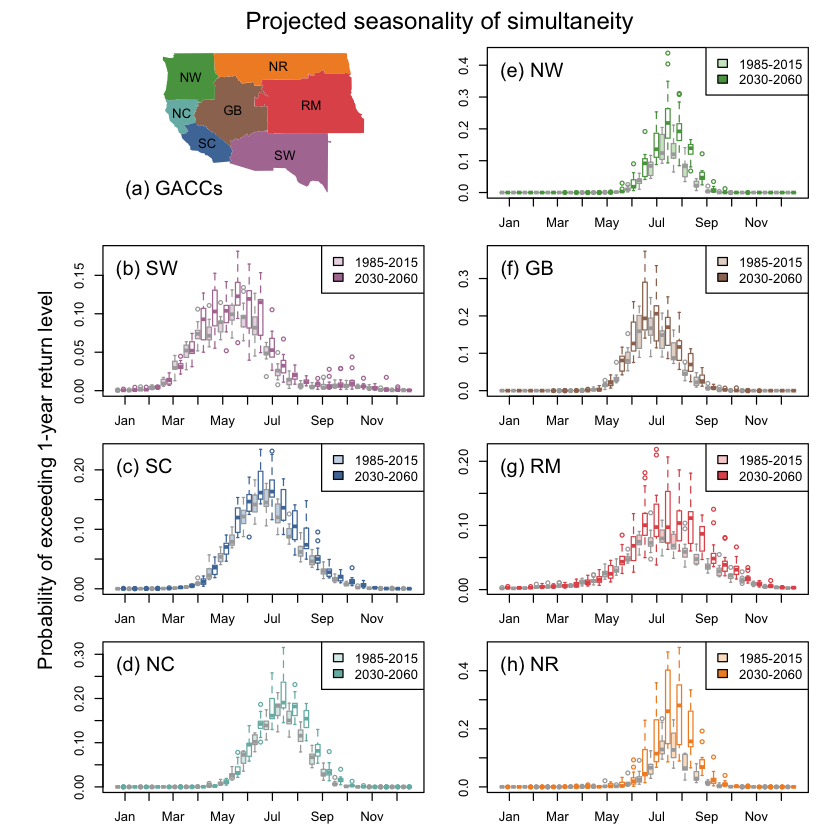
- Unless we take steps to address the situation – most of the Western US is projected to see numbers of simultaneous, 1000+ acre fires that historically occurred once every ten years happening once every five years – or even more frequently (McGinnis et al., 2022).
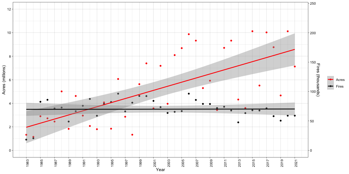
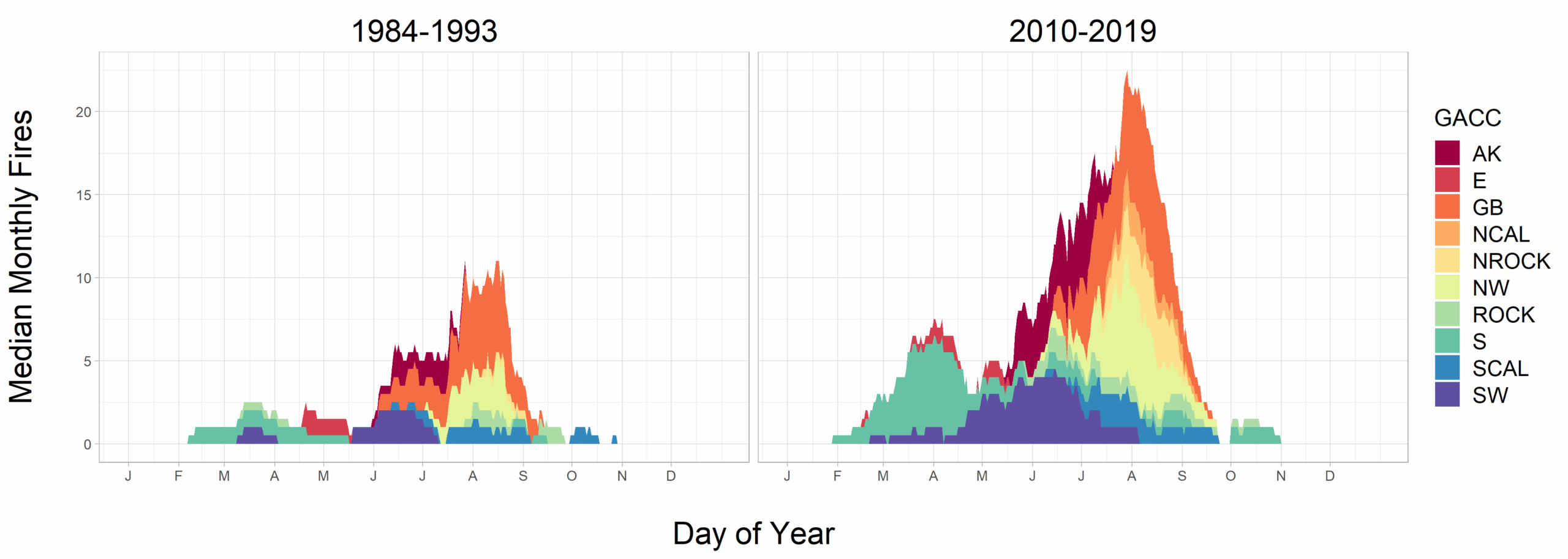
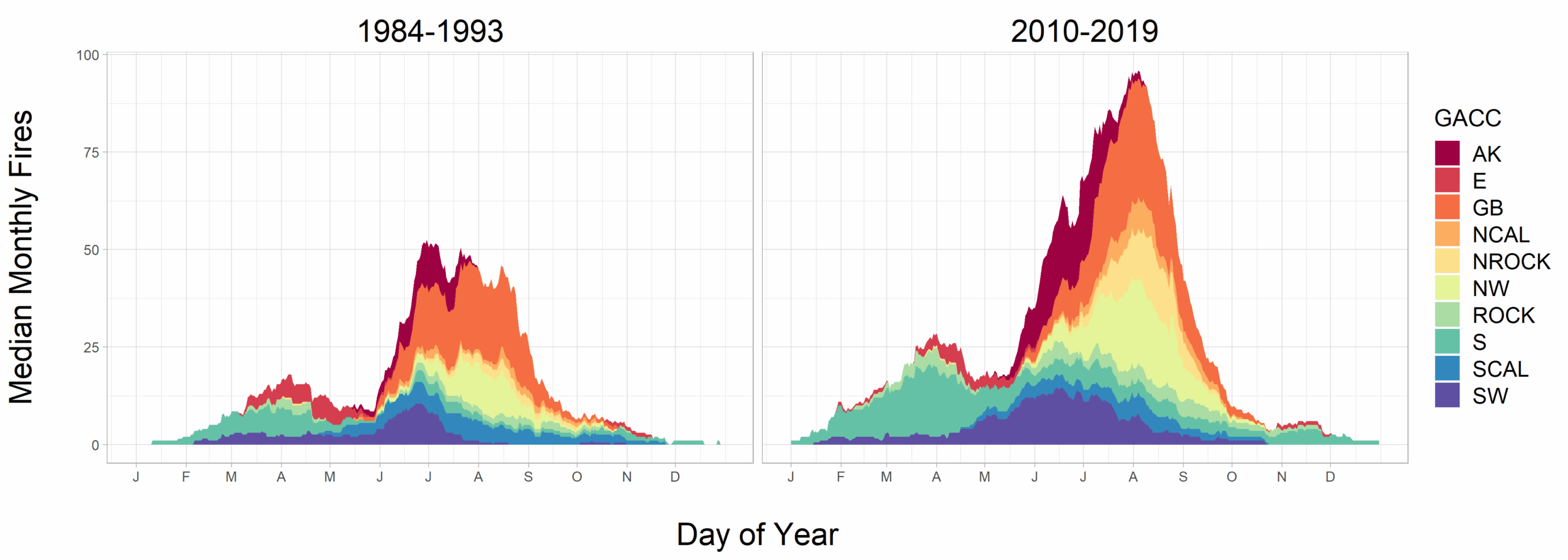
- In the US, the median number of large fires (i.e., greater than the historic 75th percentile) occurring simultaneously from July to September was about 3 times higher in 2010-2019 than it was in 1984-1993 (Podschwit and Cullen, 2020; Cullen et al., 2023).
- During the month of peak fire intensity in the US, the number of large fires (i.e., greater than the historic 75th percentile) occurring simultaneously was twice as high in 2010-2019 as it was in 1984-1993 (Podschwit and Cullen, 2020; Cullen et al, 2023).
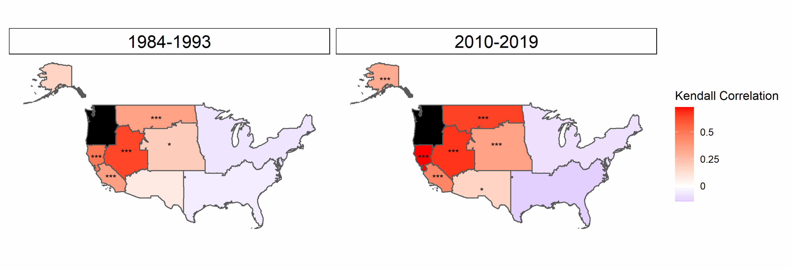
- In Alaska, the average number of large fires (i.e., greater than the historic 75th percentile) during peak fire activity months approximately doubled in 2002-2019 compared to 1984-2001. In the Northwest US, the average number of large fires during peak fire activity months increased almost 30% between these two periods (Cullen et al., 2023).
- In the Northern Rockies region, conditions of more than 35 simultaneous wildfires 1000+ acres in size, which historically occurred once per decade, are projected to occur on average every two years by the end of this century (McGinnis et al., 2022).
- Federal firefighters are earning up to 50% less per month than state firefighters in four western states, despite spending more time on the job. This pay gap poses a substantial barrier to hiring and retaining firefighters for federal roles, which has been reflected in a large percentage of open positions in some locations. (Alkhars et al. 2023).
- As periods of co-occurring wildfire increasingly overlap across US regions, competition for suppression resources has been increasing, a trend which is expected to continue and intensify. (Podschwit and Cullen, 2020; Cullen et al., 2020).
- The current capacity, in terms of hiring, staffing and preparing, of fire operations organizations is insufficient for responding effectively in the coming decades given the projected number and intensity of impactful fires. (Podschwit and Cullen, 2020; Cullen et al., 2020).
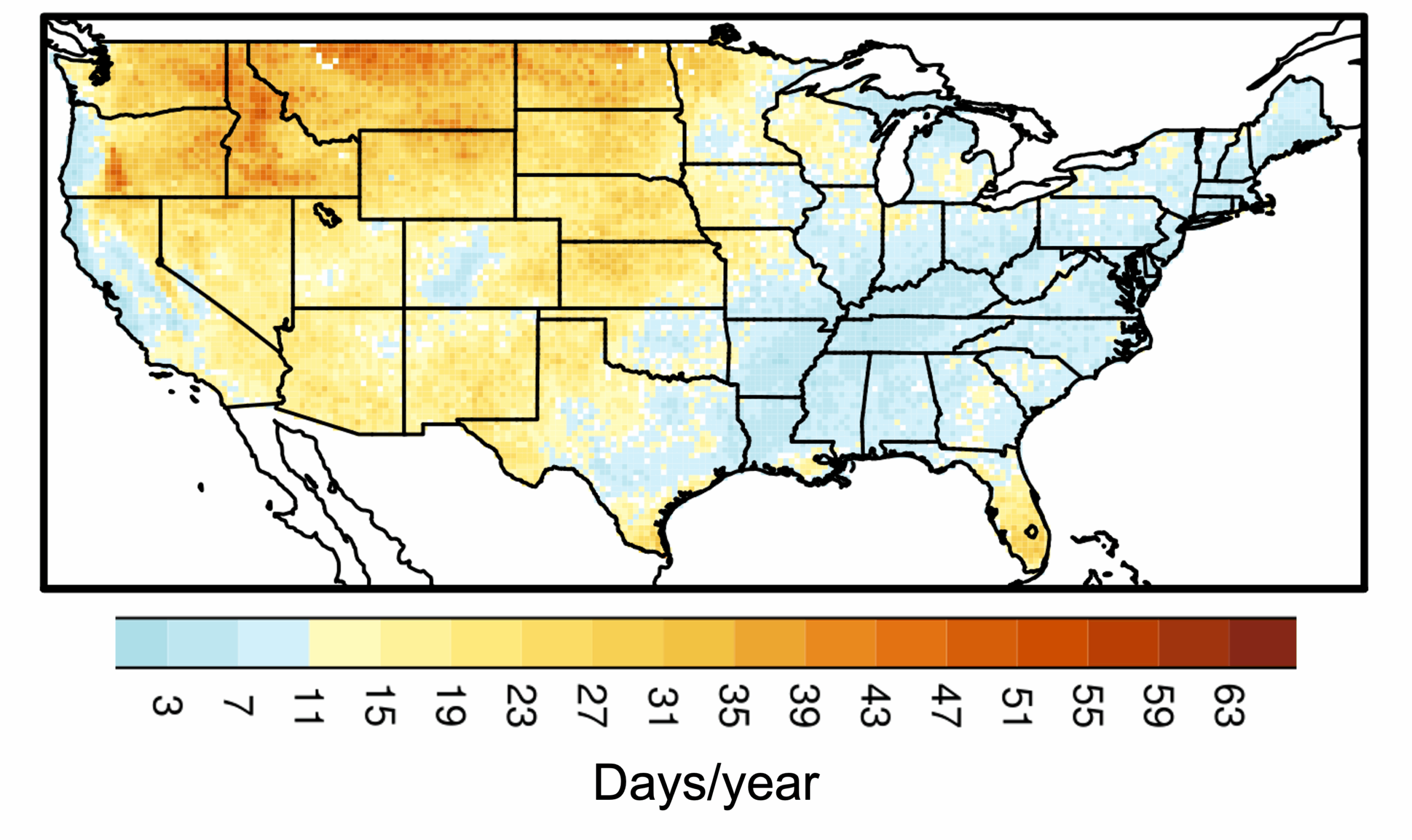
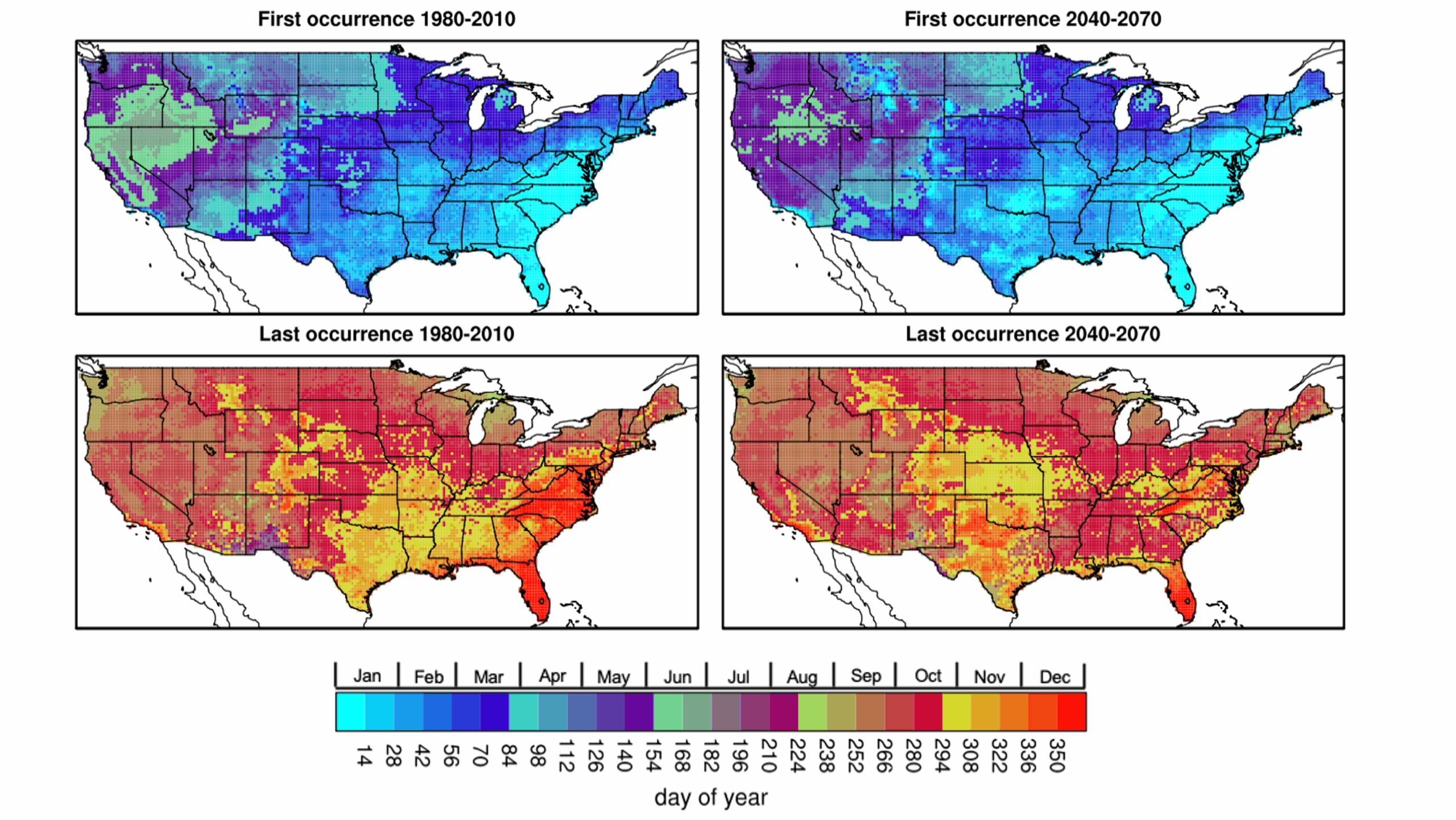
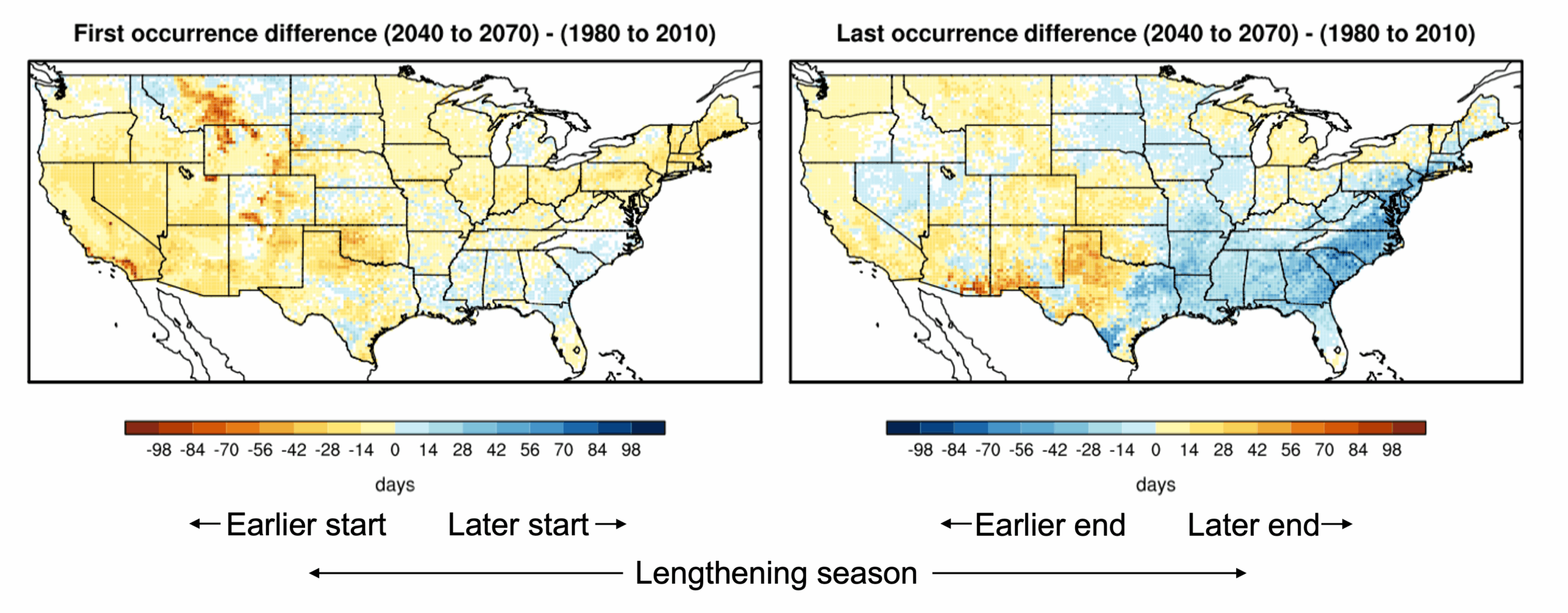
- In the Western US, the season during which wildfires compete for suppression resources is projected to begin 2-4 weeks earlier and end 2 weeks later in 2040-2070 than it did during 1980-2010. Overall, wildfire season length will increase by 4-6 weeks. (McGinnis et al., 2022).
- In 2021, the US national preparedness level reached its maximum (PL=5) at the earliest point in the year ever recorded, 14 July, indicating that suppression resources were already fully committed in response to simultaneous active fires at that date. (Abatzoglou et al., 2021).
- With increasing intensity of wildfire seasons, national resources will be subject to ever higher levels of competition, necessitating increased reliance on international resource-sharing relationships. (Bloem et al., 2022).
- Fire management in the US must become proactive rather than reactive in the face of the lengthening of the simultaneous wildfire season by several weeks, alongside a notable increase in the risk of extreme fire weather.
- In recent decades, increased area burned by western wildfires has been associated with uncharacteristically large patches of high-severity, stand-replacing fire. (Parks and Abatzoglou 2020, Hagmann et al. 2021).
- Because high-severity fire events can be catalysts for vegetation change, trends in large wildfires and burn severity have implications for rapid ecosystem shifts and declines in valued resources. (Kemp et al. 2019, Stevens-Rumann and Morgan 2019, Coop et al. 2020).
- Combining western science and Indigenous knowledge systems is foundational to intentionally restoring and adapting western forest ecosystems (Kimmerer and Lake 2001, Lake et al. 2017, Roos et al. 2021).” (Prichard et al. 2021).
- Adaptive management is a learning-by-doing method of responding to ecosystem changes, informed by effectiveness monitoring. (Lyons et al. 2008, Larson et al. 2013b).
- Restoring open forest structure and composition, favoring larger tree sizes, and reducing surface fuels can effectively mitigate future wildfire severity in dry, fire-prone forests, including oak and pine woodland and semi-arid mixed conifer forests of the western U.S.
- Despite calls to restore fire as a cultural and ecological process (e.g., The U.S. National Wildland Fire Cohesive Strategy), the dominant approach to wildfire management continues to be aggressive suppression. (Prichard et al. 2021).
- Under active fire suppression, forest infilling and fuel accumulation predisposes forests to high-severity fire when fire inevitably returns to the locations where it has been previously suppressed. (North et al. 2015b).
Press Coverage
Heat waves increase wildfire risk – a new study explains how much, and it’s not a small number (Yin), The Converation, June 17, 2026.
How much does wildfire size matter? Global data from 2025 raises questions (Abatzoglou), Mountain West News, June 15, 2026.
Wildfires are more extreme in Europe and North America, but global burning is oddly decreasing (Abatzoglou), AP, July 29, 2026.
California fire season has been quiet. A heat wave could change that fast (Abatzoglou), Cal Matters, July 29, 2026.
Heat dome burns off mountain snow in western U.S., flashing warning for fire season (Abatzoglou), BBC, March 31, 2026.
Study Finds Warming World Increases Days When Weather Is Prone to Fires Around the Globe (Yin, Abatzoglou), AP, February 18, 2026.
Wildfire disasters are increasingly in the news, yet less land is burning globally – here’s why (Abatzoglou), The Conversation, August 21, 2025.
“Fuel to the Fire” (McGinnis, Cullen) MINNPOST, June 2024.
Fueled by climate change, extreme wildfires have doubled in 20 years (John Abatzoglou), The Washington Post, June 24, 2024.
Global CO2 emissions from forest fires increase by 60% (Abatzoglou). UC Merced. October 17, 2024.
Study: CO2 emissions from forest fires have increased 60% over last two decades (Abatzoglou). Ventura County Star. October 24, 2024.
California wildfires: Why are they happening and is climate change to blame? (Abatzoglou) EuroNews. January 9, 2025.
Don’t expect to see LA-style wildfires in Las Vegas (Abatzoglou). Las Vegas Review-Journal. January 9, 2025.
It’s not really the typical time for nasty California fires. What changed that? (Abatzoglou). AP. January 9, 2025.
What are the Santa Ana winds that have driven LA fires? (Abatzoglou). LiveNowFox. January 9, 2025.
Are arsonists responsible for the Los Angeles wildfires? (Abatzoglou). NBC News. January 11, 2025.
Climate change parches Western US, providing fuel for fires (Abatzoglou). The Hill. January 11, 2025.
California fires may be among ‘costliest natural disasters in US history’; causes still under investigation (John Abatzoglou). Global Times. January 13, 2025.
‘Literally off the charts’: LA’s critically dry conditions stun scientists as fires rage (Abatzoglou). CalMatters. January 15, 2025.
A new kind of urban firestorm (Abatzoglou). The Washington Post. January 16, 2025.
Climate change made conditions that fed California wildfires more likely and intense, preliminary study finds (Abatzoglou). PBS. January 28, 2025.
Climate change caused hot, dry conditions that made LA wildfires 35% more likely: WWA (Abatzoglou). DownToEarth. January 29, 2025.
EOS: How much did climate change affect the Los Angeles wildfires? (Abatzoglou). Maven’s Notebook. January 29, 2025.
What old trees can teach us about wildfires (Abatzoglou, Prichard). The Washington Post. March 11, 2025.
Researchers Look Ahead to Fire Season 2025 (Abatzoglou). UC Merced. April 22, 2025.
How bad will California wildfires be this summer? Experts weigh in on forecast ( Abatzoglou). The Sacramento Bee. May 16, 2025.
Yes, ‘zombie fires’ can happen in the Pacific Northwest. Here’s how they work (Prichard) King5News. July 15, 2024.
Wildfire Series 3 explain how climate change makes wildfire seasons worse Project Optimist April 2024.
How years of fighting every wildfire helped fuel the Western megafires of today FreeThink.com, Jun 4, 2023
Talking Points: The health risks from Minnesota’s hazy skies CBS News Minnesota. June 21, 2023
California is seeing more days of fire weather. Map shows areas with biggest spikes San Francisco Chronicle. May 24, 2023
Western organizations push back on lawsuit seeking to restrict aerial fire retardant use Northwest Public Broadcasting. March 15, 2023
Does Thinning Work for Wildfire Prevention High Country News. February 2023.
In the Northwest and beyond, mature and old-growth trees remain under threat in spite of Biden’s move to protect them InvestigateWest. September 2022.
Fire danger escalating in Northern California as McKinney blaze erupts Washington Post. July 30, 2022.
August is coming. Prepare for climate calamity Los Angeles Times. July 28, 2022.
Prescribed fires: Why they’re still trusted despite runaway blaze Christian Science Monitor. July 19, 2022.
Climate change: wildfire risk has grown nearly everywhere – but we can still influence where and how fires strike, The Conversation. June 30, 2022.
Briefing with President Biden – climate crisis and Executive Order strengthening America’s forests, boosting wildfire resilience, and combating global deforestation. April 2022.
The Return of Intentional Forest Fires: Scientists look to Indigenous practices Bioscience. March 17, 2022.
Western US’s Worst Drought in 1,200 Years Brings Year-Long Fire Season Truthout. 13 March 13, 2022.
‘In wildfire ‘pivot’ experts question federal focus’ Roll Call. January 28, 2022.
For Forest Blazes Grown Wilder, an Alternative: The ‘Good Fire’ Undark. October 25, 2021.
Local fire ecologist addresses forest management debate Methow Valley News. September 1, 2021.
Experts call for expanded wildfire prevention tactics as fire seasons become more extreme Yakima Herald-Republic. September 7, 2021.
An Update on This Year’s Wildfires: It’s Bad! The Stranger. August 26, 2021.
Wildfires grow worldwide as climate sizzles Associated Press. August 13, 2021.
Forest management not so clear cut Street Roots. August 17, 2021.
Wildfires: How are they linked to climate change? BBC. August 11, 2021.
What The UN’s Latest Climate Report Means For Colorado Colorado Public Radio. August 9, 2021.
How years of fighting every wildfire helped fuel the Western megafires of today The Conversation. August 2, 2021.
State of the science on western wildfires, forests and climate change UW News. August 2, 2021.
US heatwave: Could US and Canada see the worst wildfires yet? Reality Check Team, BBC. July 13, 2021.
States spend big as water levels fall, raising risks for catastrophic fires The Hill. June 29, 2021.
Software, Data Products
All software and data products generated by this project are publicly available. The code and documentation that we have developed for calculating fire indices in support of climate projections is publicly available on GitHub. Visualizations appear in both published papers and above on this page.
burn_viz is a web application that allows users to visualize relationships between wildfire occurrence, the location of human populations, and different landcover types. Understanding these relationships is crucial for risk assessment and policymaking, but it can be challenging to navigate data from disparate sources that may be provided in different formats and spatial resolutions. Integrating these elements into a interactive visualization creates an opportunity to explore how wildfire, population, and landcover interact over space and time.